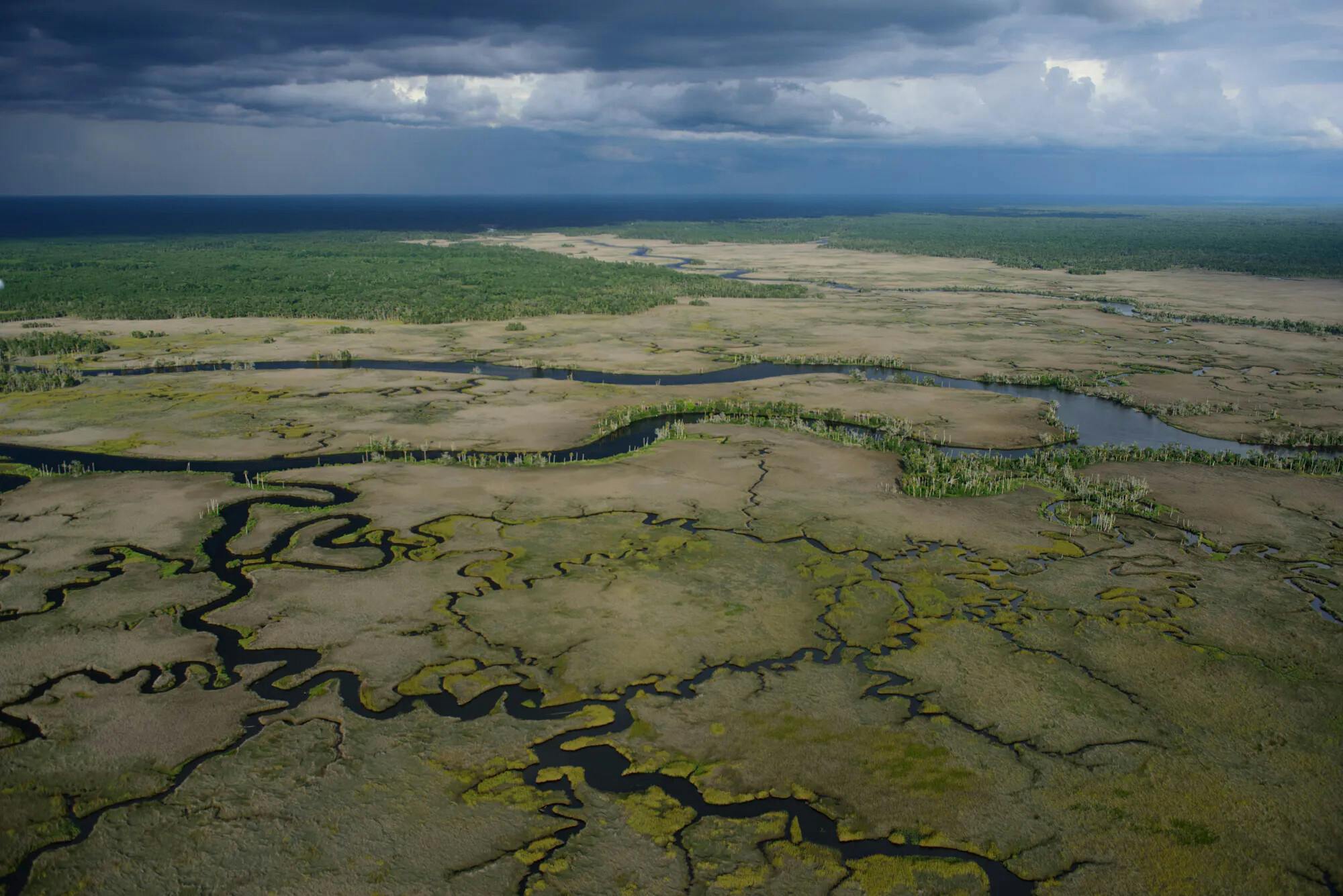
 Photo by: Carlton Ward, Jr.
 The Florida Wildlife Corridor protects critical floodplains.
What are Floodplains?
Floodplains are areas of land adjacent to rivers and streams that are subject to flooding during heavy rainfall. They're typically flat or gently sloping from the river or stream up to a higher level land feature such as a bluff or hill.
Because of Florida’s low relief and periodically heavy rainfall, water frequently overfills stream channels and spills onto floodplains and adjacent lakes and wetlands.
-1.webp&w=3840&q=75) Adapted from Wired.com
Adapted from Wired.comWhy Are Floodplains Important For Protecting People and Property?
Floodplains play several crucial roles in protecting people and property from the harmful effects of flooding:
1. Natural Flood Storage and Conveyance: Floodplains naturally absorb and slow down the flow of excess water during times of heavy rainfall or snowmelt, thus reducing the speed and volume of floodwaters downstream. By serving as a sort of "buffer zone," they help to lessen the risk and severity of floods, protecting communities and properties that might otherwise be in harm's way.
2. Sediment Capture: Floodplains capture sediment from floodwaters, which can help to reduce the impacts of erosion and sedimentation downstream. This is particularly beneficial for maintaining the health of water bodies and for protecting infrastructure like harbors, bridges and dams.
3. Groundwater Recharge: When floodplains absorb water, they can contribute to the replenishment of groundwater reserves. This groundwater can serve as a critical water source during dry periods and helps maintain river flows.
4. Risk Indicator: The presence of a floodplain can indicate areas of high flood risk. This can guide planning and development decisions, helping to avoid placing vulnerable infrastructure and residences in areas prone to flooding.
Floodplains have significant ecological importance. They provide diverse habitats that support a wide variety of plant and animal species, and they often serve as important corridors for wildlife movement. The periodic flooding of these areas helps deposit nutrient-rich sediments, which can enhance soil fertility and support productive agricultural lands.
Despite these natural benefits, human development often encroaches on floodplains, reducing their effectiveness at flood mitigation and increasing the vulnerability of those areas to flood damage. For this reason, it's important to manage floodplains responsibly, taking their vital role into account in land use and urban planning decisions. This can include measures like preserving natural floodplain environments or even relocating existing structures out of flood-prone areas.
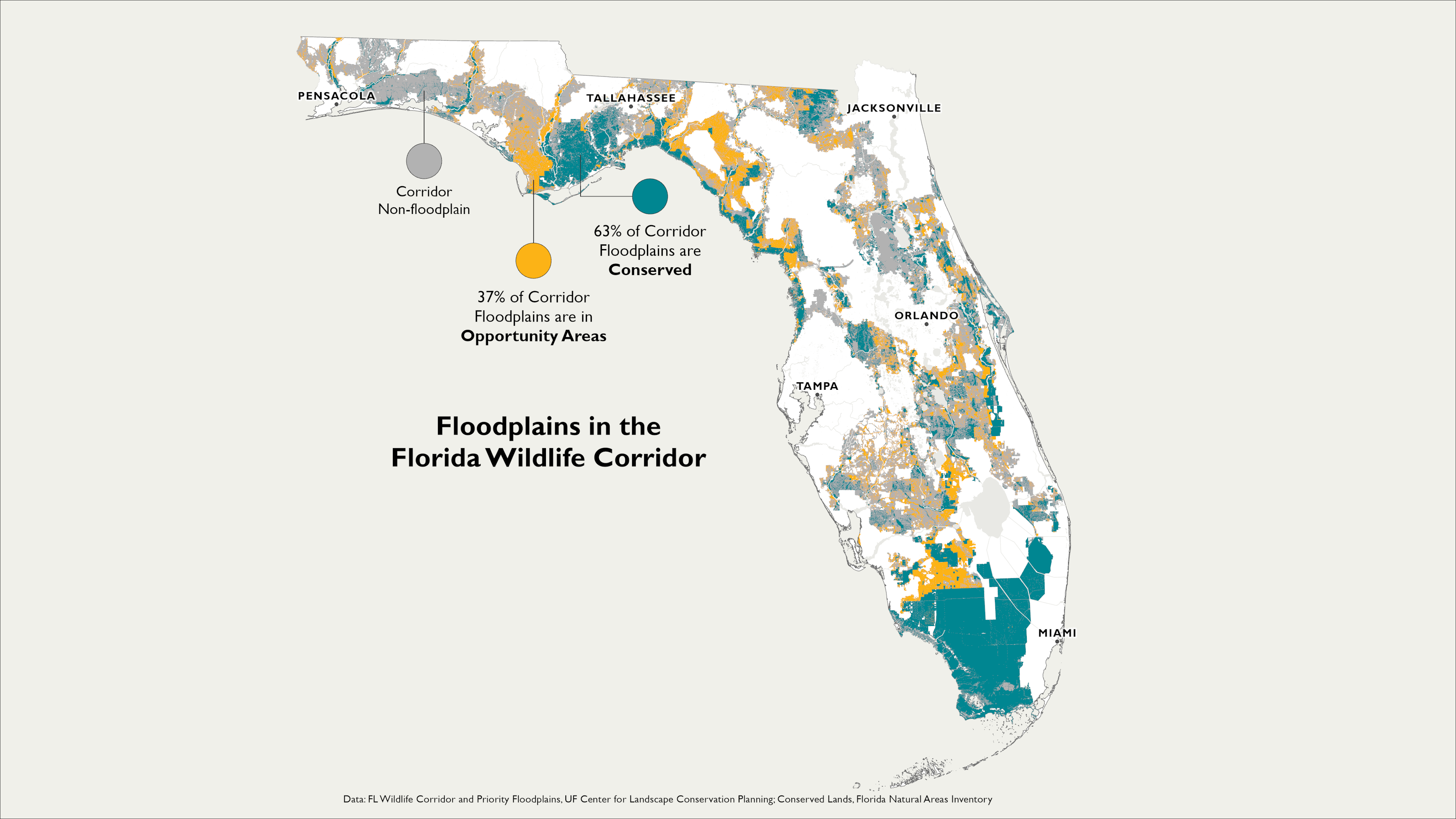
By protecting inland floodplains, the Corridor defends both inland and coastal areas from downstream flooding. About two-thirds of Florida’s 15 million acres of natural floodplains are located in the Corridor. 63% of these are conserved and 37% are in opportunity areas, yet to be conserved. Wise planning avoids permitting development of floodplains to protect human lives while avoiding higher future costs of flood damage.
Floodplains and Hurricanes
Floodplains play a crucial role in mitigating the impacts of hurricanes, particularly the flooding associated with these storms. Here's how:
1. Water Absorption and Storage: Floodplains can absorb and store significant amounts of rainwater. During a hurricane, which often brings intense rainfall, floodplains can serve as natural reservoirs, reducing the amount of runoff that might otherwise contribute to flash floods and urban flooding.
2. Slowing Down Floodwaters: By spreading out and slowing down floodwaters, floodplains can help reduce the velocity and erosive power of floods. This can help protect downstream areas from damage.
3. Sediment Trapping: Floodplains can capture sediment carried by floodwaters. This sediment deposition can potentially create a natural barrier, providing some protection against future flood events.
4. Natural Buffer Zones: By serving as a buffer zone between water bodies and human development, floodplains can reduce exposure to flooding during hurricanes.
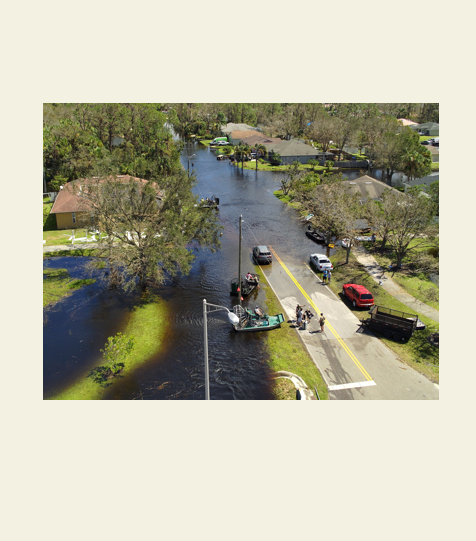
The crucial role of floodplains was exemplified during the devastation wrought by Hurricane Ian in 2023. The hurricane highlighted the significance of floodplains as natural buffers that absorb and store excessive water, mitigating the overall impact of the storm on the surrounding communities. As the hurricane deluged the region with heavy rains, these low-lying areas adjacent to rivers absorbed and stored vast amounts of water. By spreading out the floodwaters over a larger area, these plains provided a necessary relief for overwhelmed drainage systems, which reduced flooding for human settlements located further downstream. Without floodplains, flooding in the wake of Hurricane Ian could have been even worse! However, it’s important to note that floodplains alone cannot entirely eliminate the risk associated with such massive storms. It’s important to integrate these natural systems into broader climate resilience and disaster risk management strategies.
The Consequences of Developing Floodplains
Human development and land use changes can greatly alter the natural functions of floodplains. Development in floodplains, for example, can increase flood risk by reducing the land's ability to absorb and store floodwaters. It can also disrupt the ecological benefits that floodplains provide. That’s why managing these areas sustainably is critical for both human and environmental health.
When floodplains are developed, it can lead to:
1. Loss of Water Absorption Capacity: If floodplains are destroyed, this water-absorbing capacity is lost. This could lead to more rapid runoff and a higher volume of water flowing downstream toward the coast, exacerbating coastal flooding.
2. Increase in Peak Flows: Floodplains also reduce the peak flow of rivers during flood events. When a floodplain is destroyed, the river may experience higher and faster peak flows, which can increase the risk of downstream and coastal flooding.
3. Alteration of Natural Flood Cycles: Healthy floodplains help to maintain the natural flood cycle, absorbing water during periods of high discharge and slowly releasing it back into the river system. The destruction of floodplains can disrupt these natural flood cycles, potentially leading to more severe and frequent flooding.
What’s the difference between a floodplain and a flood zone?
Floodplains and flood zones often overlap, as they both refer to areas that are prone to flooding. However, there are important differences between the two terms. A floodplain is a naturally occurring geographic feature, a low-lying area adjacent to a river, stream, or other body of water, that is subject to flooding under natural conditions. On the other hand, a flood zone is a regulatory term used in the context of flood risk management. Flood zones are delineated based on estimated flood risks, taking into account factors such as historical flood data, local topography, and the characteristics of nearby bodies of water. Flood zones are often used for purposes such as setting flood insurance rates and guiding land use and building decisions. So while floodplains and flood zones are related, a given floodplain might encompass multiple flood zones, each with a different level of flood risk. Conversely, a given flood zone might include parts of multiple different floodplains. This can depend on a variety of factors, such as local topography, hydrology, and the specific methodologies used to delineate flood zones.
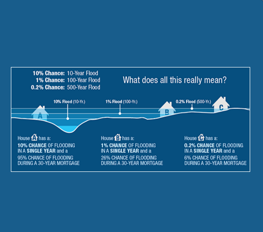
What is a “100-year floodplain”?
The term "100-year floodplain" is a risk classification term, referring to an area that has a 1% chance of being flooded in any given year. It's important to understand that this does not mean such floods will only occur once every 100 years. Instead, it's a statistical way to represent flood risk. The term "100-year flood" is used in hydrology to express a large flood event with a 1% probability of occurring in any given year based on historical flood data. It's a statistical average, and it's entirely possible for "100-year floods" to occur in consecutive years or multiple times in a short period.
The "100-year floodplain" is the area that would be inundated during a 100-year flood event. It's often used as a standard for floodplain management and to determine the need for flood insurance. For example, in the United States, if you have a federally backed mortgage on a home located within a 100-year floodplain, you are required to have flood insurance by the Federal Emergency Management Agency (FEMA). However, climate change is altering rainfall patterns and increasing the frequency and severity of extreme weather events, including floods. This means that areas currently classified as 100-year floodplains may face higher flood risks in the future. These changes underscore the importance of adaptive flood risk management strategies.
 FEMA
FEMAKey References:
- Brody, S. D., Zahran, S., Maghelal, P., Grover, H., & Highfield, W. E (2007). The rising costs of floods: Examining the impact of planning and development decisions on property damage in Florida. Journal of the American Planning Association, 73(3), 330-345.
- Brody, S. D., Highfield, W. E., Ryu, H. C., & Spanel-Weber, L. (2007). Examining the relationship between wetland alteration and watershed flooding in Texas and Florida. Natural Hazards, 40, 413-428.
- Brody, S. D., Davis, S. E., Highfield, W. E., & Bernhardt, S. P. (2008). A spatial-temporal analysis of section 404 wetland permitting in Texas and Florida: Thirteen years of impact along the coast. Wetlands, 28, 107-116.
- Brody, S. D., Bernhardt, S. P., Zahran, S., & Kang, J. E. (2009). Evaluating local flood mitigation strategies in Texas and Florida. Built Environment, 35(4), 492-515.
- Costanza, R., Pérez-Maqueo, O., Martinez, M. L., Sutton, P., Anderson, S. J., & Mulder, K. (2008). The value of coastal wetlands for hurricane protection. Ambio, 241-248.
- Highfield, W. E., & Brody, S. D. (2006). Price of permits: Measuring the economic impacts of wetland development on flood damages in Florida. Natural Hazards Review, 7(3), 123-130.
- Hughes, F. M. (1997). Floodplain biogeomorphology. Progress in physical geography, 21(4), 501-529.
- Kang, J. E. (2009). Mitigating flood loss through local comprehensive planning in Florida. PhD Dissertation. Texas A&M University.
- Knox, R. L., Wohl, E. E., & Morrison, R. R. (2022). Levees don't protect, they disconnect: A critical review of how artificial levees impact floodplain functions. Science of The Total Environment, 155773.
- Opperman, J. J., Luster, R., McKenney, B. A., Roberts, M., & Meadows, A. W. (2010). Ecologically functional floodplains: connectivity, flow regime, and scale 1. JAWRA Journal of the American Water Resources Association, 46(2), 211-226.
- Sun, F., & Carson, R. T. (2020). Coastal wetlands reduce property damage during tropical cyclones. Proceedings of the National Academy of Sciences, 117(11), 5719-5725.
- Taylor, C. A., & Druckenmiller, H. (2022). Wetlands, flooding, and the clean water act. American Economic Review, 112(4), 1334-63.